In this webinar, the Jane Goodall Institute’s Vice President of Conservation Science, Dr. Lilian Pintea, discusses his decade of experience at Gombe Stream National Park and in Tanzania. Dr. Pintea, who specializes in using mapping tools and satellite imagery to track changes in chimpanzee habitat, speaks with JGI’s Shawn Sweeney in this Q&A on Dr. Pintea’s experience, the development of science technology at Gombe and the connection between behavioral data, habitat data and conservation efforts.
So Lilian, just getting started, we want to know more about your background with Gombe, and when you were doing your graduate studies, why you chose to study at Gombe. And also your work with JGI toom – what brought you to JGI? And just a little bit on your history.
Right. Well, I really loved, thanks to my dad and numerous hiking trips when I grew up in Moldova in Eastern Europe, I really loved wilderness and working with animals and observing animals, so I was really impressed by a book called “Serengeti Shall Not Die” and started dreaming about working in Africa. I got my masters degree in biology at the University of Moscow in Russia and I started using satellite imagery around maybe more than 25 years ago. When I came to the Unites States in ‘96, immediately in ‘97 I already started working in Africa, and I worked at the World Bank, mostly in advising on GIS and mapping projects over the years. And I felt that I really would like to learn, what does it mean to be a scientist, in terms of bringing science to conservation practice. So I was looking at programs and Gombe, and chimpanzee research at Gombe was just one of the possibilities—which I took.
So can you talk a little bit about once you got started with your graduate studies at Gombe, what that entailed?
Right. So what I did was I complemented the longest chimpanzee behavior study which we have going at Gombe. My previous students and colleagues had already digitized more than 400,000 observations, going all the way back to the 1960’s and ‘70s. What I did is I complemented these behavior data sets with how the habitat changed as detected by historical aerial photos and also satellite imagery. And I combined them together into a system, a mapping system called GIS which allows us to store, manage, relate and analyze any geographic data.
Cool! So that means that the behavioral research that Jane herself started in the ‘60’s and continued through today – people have been tracking the chimpanzees and covering their behavior with their data monitoring – you were able to complement that with maps that showed how the habitat has changed over time. So, is the hope with that the behavioral data can be paired up with the habitat change and that certain conclusions can be drawn from it?
Well, we live in a geographic world, right? So once you put chimpanzee data spatially and integrate it with habitat data spatially, it opens a huge amount of possibilities to relate it to distribution of people, how the people are using the land, how the chimpanzees are using the forest, how the forest is changing, how climate is changing, how the hydrology is changing. So, it opens fast possibilities to reintegrate some of the Gombe research into the larger landscape and ask questions which go way beyond chimpanzee behavior and relate to the two issues from understanding how human and chimpanzees can coexist and share the land to what is the impact of climate change and what is the best way to adapt also the chimps and the people.
Awesome. So thinking about Gombe as a research site, and where it is in Africa, what are some of the biggest challenges that you and other researchers face in working at Gombe?
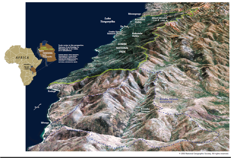
I have a map right here which I wanted to share with you, and this was the first map which was published by National Geographic. It’s the first view of Gombe from very high resolution satellite imagery, coming from the Ikonos satellite back in 2001. And you could see that Gombe, it’s a very small park surrounded by an ocean of humanity basically. Villages, farms and a lot of other human land use.
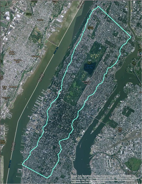
If you go to the next slide, to put Gombe’s size in perspective, I overlaid Gombe National Park which is here in light green over Manhattan and Central Park and you can see that it’s a pretty small park. It’s only 35,000 square kilometers or 3,500 hectares [Misspoken: Gombe Stream National Park is 35 square kilometers]. So the size of Gombe and the shape of Gombe is one of the major challenges in conservation biology practice and science in order to manage the potential threats to the park.
Another challenge which we have of course it that Gombe is located in Western Tanzania near the border with Burundi, and the place has been experiencing one of the highest population growth rates of the last 60 years. We’re talking about 4.8 percent a year—this is one of the highest growth [rates]in Africa. It’s also a very marginalized and impoverished area. So the human factor, it’s a big challenge. Finally the political dynamics, the changes and people’s priorities, this is also a challenge which keeps us busy and the conservation work may never be done basically. You always have to be focused and alert.
So on the flip side of that, what do you think in terms of JGI’s work at Gombe, your own work, the work of our partners? What do you think have been some of our greatest successes in our recent past at Gombe?
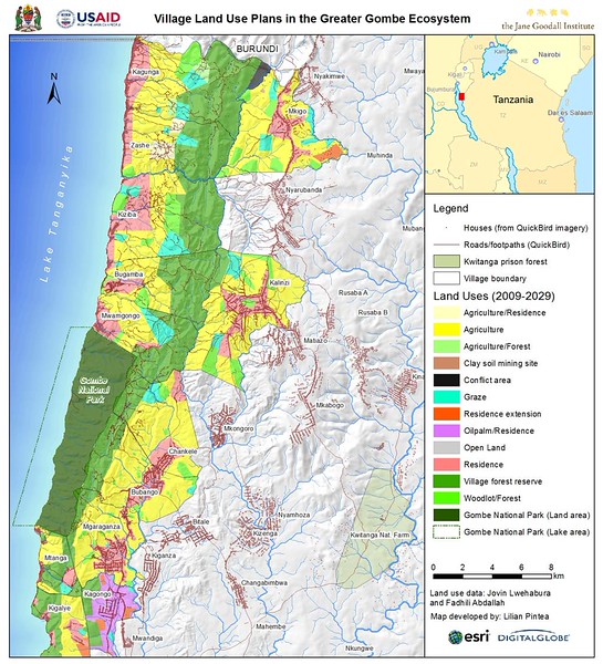
Well if you go to the next slide, I love this slide because on one hand it shows the challenges. What you’re looking at here is Gombe National Park in the dark green, surrounded by different village land use, land users and also a distribution of food paths and roads and all the dots that you see there are houses which we mapped with 40 cm satellite imagery, and you can see the challenge, right? But also this map gives me a lot of hope because this map is a product of many years of JGI work with communities. And this is the final land use plan which was approved and developed by the local communities, facilitated by JGI, which established village forest reserves, along with other forest and land uses, which connects Gombe now with other chimpanzee populations which still exist in Burundi. As you can see, Gombe is connected with this corridor of village service reserves which basically, together with Gombe, creates a naturally protected areas for chimps and studies outside the park.
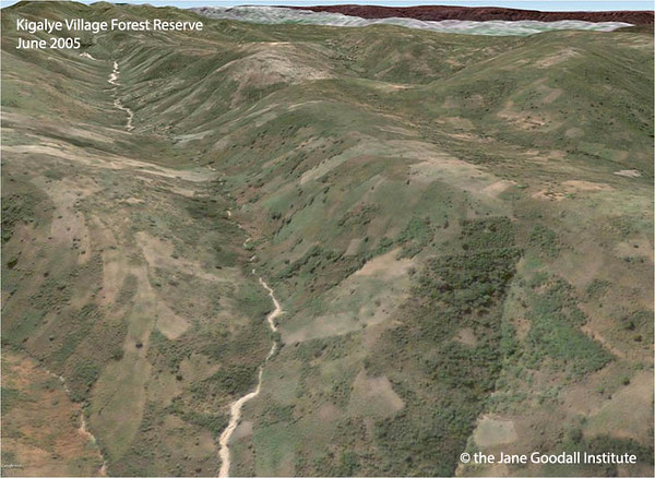
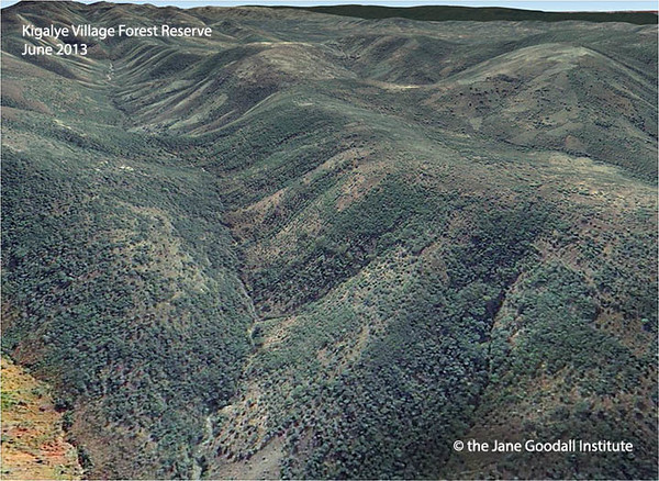
Another example if you go to the next slide is that this map is not just a map: it’s a living document. And actually, it’s the communities embracing it and actually implementing it. So for example let’s zoom into one of these village forest reserves. In this case, it’s Kigalye Village. This is how the forest reserve looked back in 2005 when we just started the land use planning work and the forest restoration work. You can see the graded hills—all those hills used to have forests you’d see covered in trees. You see a lot of farms, some of them abandoned, some of them in use. You can see the stream at the bottom of the valley full of sediment from all the erosion. And look at the next slide. This is how Kigalye Village Forest Reserve looks now in 2013. And the latest 2014 and 2015 imagery shows the reforestation is continuing. Huge improvement.
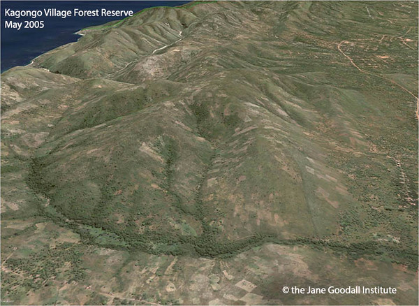
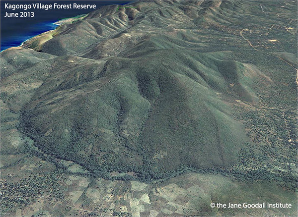
And we see similar patterns happening in many village forest reserves in the landscape. Again, for example, this is how the village forest reserve looked in Kagongo back in 2005, and this is how the forest reserve looked in 2013. So these are pretty exciting changes which I’m very proud of.
Great, ok. So, you mentioned in talking about this that JGI has a conservation action plan for Western Tanzania. Can you talk about the conservation plans in how it relates to Gombe?
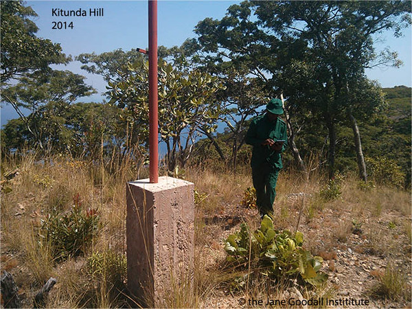
Absolutely. But before that, let me show you a couple of more slides. So one of the advantages of working with the Jane Goodall Institute for now more than ten years is that it allows you to see changes personally. And put in a kind of personal context. Ten years is a lot of years for maybe an individual but it’s a limited amount of time for a landscape or a forest. And seeing changes—it’s truly remarkable. So for example in 2001, I was invited by Tanzania National Parks for the first time to help map the boundary of Gombe National Park. Because of the past conflicts with local communities, and the way how the park was established back in 1968, the park was never mapped. The boundaries were always disputed. So we found ourselves on this hill and you can see how degraded it is, the surroundings. And we’re trying to decide if this is the right hill to put a boundary.
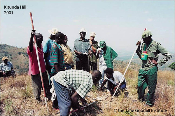
Well in 2014, with the Google Street View team, I found myself on the same hill. And I didn’t recognize it because, as you can see, there are more trees. There are more trees and this is part of those village forest reserves which I was just talking [about]before. I’m also very excited about JGi work, at least personally I’m very excited, that a lot of science and technology tools that we have been bringing to the table. It empowers our main stakeholders which are local communities, to be more fully participants in protecting their own natural resources. So even for example this picture of exploring Gombe boundary, now everyone in the world can take a tour using Street View and following the boundary.
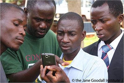
I’m also incredibly proud of the work JGI did with adopting mobile technologies. This is the local community being trained in how to use the mobile tools such as smartphones and tablets a a free app called Open Data Kit, or ODK Collect, to monitor and record what’s happening on the forest reserves.
These are just examples of the imagery which they have been collecting over the years. You can see on the right that they have the location of a chimpanzee nest. This is a chimp nest on Mitanga Village which is outside the park.
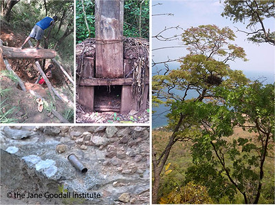
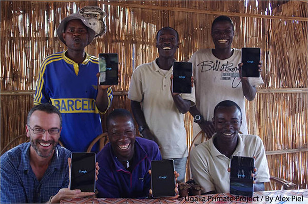
You can also see the threats. For example the cartridge, the sawmill, which are scattered in the landscape, including a wildlife trap which had never been recorded before. And this mobile tool, again, has just been spreading to other JGI projects. This is the same technology and forms and apps used in Uganda with our community partners and our National Forest Authority partners and our partners in research. Here is Ugalla Primate research, one of our main partners in Masito and Ugalla and the greater Mahale ecosystem, studying and monitoring and observing chimpanzees outside protected areas in Tanzania and also using the same technology. So these are a couple technologies which again make me very proud of what JGI has been accomplishing.
So when it comes to our approach, these technologies and the results, they are tools, they are basically tools. And the framework in which we are applying them is, as you said, is conservation action planning. The reason why conservation action planning is so important is because one of the early challenges which we have is keeping track of how our funding and conservation strategies, such as let’s say community interventions are related to our mission and our conservation goals, which is protecting chimpanzees and their habitats. Through conservation planning, it allows us not only internally with JGi, but with our major partners, to sit down and go through a very structured, transparent process which you can see here. It’s an adaptive management process which means that we can bring the best science to the table but not wait until more science is available. We can still use expert opinion but treat our management strategies as high positives. And as we’re collecting data to monitor our impact, we can adapt basically to new information and new challenges. This helps us be much more organized in using few conservation dollars, to leverage it and achieve the maximum conservation impact. And the methodology which we are using is Open Standards for the Conservation of Biodiversity. There’s a variety of organizations which have been adopting this, the Jane Goodall Institute being an early adopter, one of the first, I think, NGOs adopting Open Standards in Africa, going back to 2005, 2006. And I guess another important part about Open Standards is that the focus is not on developing a document or a plan, the focus is on planning. So it’s a process, it’s a living process, which gets adopted. For example the Gombe Conservation Action Plan was developed between 2006 and 2009; but recently, in 2015, in March, we just did a review of it. So it’s a living document, it’s a process.
So how does Gombe fit into the conservation action planning that JGI has been doing for Western Tanzania?
Well Gombe was the first site or landscape where the CAP methodology was applied and tested and adapted to the conditions in Africa. But when you do conservation planning, or you do any conservation work, you have to understand what you’re trying to conserve, in this case chimpanzees. And you have to understand, What does it mean to be a chimp? You also have to understand what are the factors which help chimpanzees survive and be viable as an individual, as a population, as a community. So most of the time we don’t see chimpanzees in the wild. Chimps are very weary about people; you see maybe nests, but you don’t have an opportunity to actually observe and learn, What does it mean to be a chimp? Well, Gombe of course is the longest chimpanzee research site in the world and we have a huge amount of data starting from the individual, physiological, molecular level to the landscape and the long-term perspective in terms of how chimpanzees and habitat and relationships are changing. So Gombe has been very important in providing the baseline data which allowed us, for example, when we scaled up and did a national chimpanzee conservation action plan in Tanzania, [to use]Gombe data together with some data from another long-term research site, from Mahale, to basically build our population habitat ability. And that data basically drives our conservation decisions.
That’s amazing. So, in coming up with the conservation decision, then developing our conservation action planning, what have been some of the biggest influences you think while working on that work?
I think they [JGI] have been one of the pioneers in bringing geospatial technology to the work of conservation planning – this including a number of tools such as GIS, which I mentioned before. Another contribution which has been quite significant is how you bring human livelihoods into the conservation planning. And JGI and partners work on applying those standards in Africa and use it towards that understanding—how to properly reflect and integrate people’s livelihoods into the conservation. I would say that our partnership with The Nature Conservancy early on helped us a lot in again bringing the latest conservation planning science practice to this job. Partnerships in general, whether it is with the zoological society, have been influential in not only developing these CAPs, but implementing them. The fact that we all have to buy into these plans that form the way we design our conservation projects and the way we work together and coordinate a major achievement.
You mentioned in a lot of this work that we involve local communities. Can you talk a little more about some of those ways? I know you mentioned forest monitoring, but from the conservation perspective as well, what are some of the ways that we involve local communities?
If you go to the next slide, I love this next slide because what you see here is villagers etching in the sand on the ground the location of the village forest reserve and how it relates to the larger land-use plan which they had been working on. And you see the village forest reserve which had been marcated there by those leaves which had been placed on the ground. Well, that location of the village forest reserve has been informed by GIS analysis of historical area where the forest used to be going back to 1947, how the landscaped changed, where the people were, where is the right place to put the forest so it not only helps chimpanzees but also watersheds and water sources, and that’s why it has the biggest impact on people’s livelihoods as well.
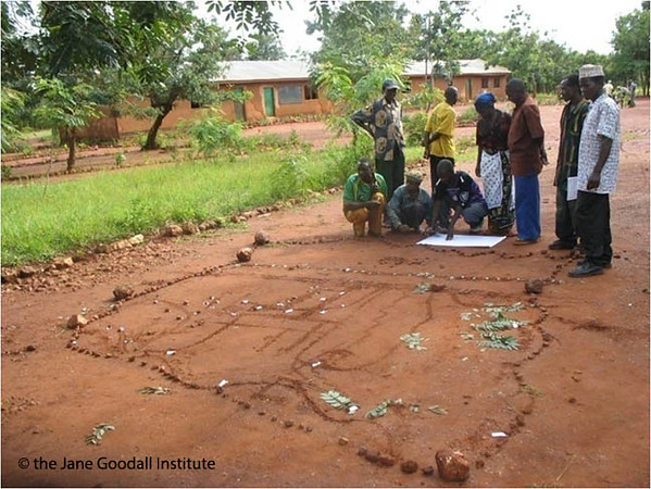
So a lot of work had happened before getting to that map in the dirt, but then the Jane Goodall Institute is facilitating the process. This is villagers’ and communities’ process in terms of managing their land. So as facilitators, we are providing access to this information, providing access to technologies, but we are listening and we are listening to their concerns and needs and we are listening to their local knowledge as well. So in this case, they prefer to start with a map on the ground, but then that map was informed and integrated with the technologies and then the final map from the ground has been georeferenced with other GPS technologies and brought back into GIS.
I think the major part of how we work with local communities is again we truly respect their rights to the land and we respect (in addition to science) their local knowledge and we are making a big effort in adopting technology in the right level and integrating the local knowledge with the science and technology. We are respecting their decisions on village land-use plans and we empower them with whichever technology or science or capacity or training. We empower them to implement these plans. Finally, the role of JGI is a facilitator. We are basically facilitating this process.
So with that work that has been done with land-use planning, do those efforts connect or feed any of JGI’s other efforts with communities around Gombe like addressing health concerns or sustainable livelihoods?
Well, the way that the conservation action plan goes and has been designed, it indicates that Gombe has been directly connected to protecting ecosystem function such as water quality which people depend on. By conserving forests and conserving forest ecosystems, there are a lot of benefit which communities are getting in return which I think the people see as the difference. With the changes in climate, the region is predicted to experience extreme drought or extreme rainfall. This means that if you have steep watersheds as you saw where people live around Gombe without the forests, the vulnerability to erosion and landslides and all sorts of disasters is just huge. I think people have seen this increase and have been truly interested in forest conservation to watershed management. Yes, I think that this is supporting the ecosystem function, supporting land-uses that have, on one hand, have allowed people to farm and allowed people to have grazing areas at the same time as trying to maintain the ecosystem functions so they are working more or less properly. It is a major focus here.
Great! We kind of talked about your background with Gombe and the work that you are doing today in that region of Tanzania. What I was hoping we could do now is come back to the science that is going on at Gombe and talk about the future at Gombe. I was wondering if you could talk a little about where you see the science going in the future.
This is a great question. First of all, I hope that the long term research at Gombe continues. Gombe is already the longest chimpanzee research station in the world and there are numerous advantages of keeping this going simply because chimpanzees are long-living animals and there are so many things that we are just learning looking at a long term data set that we would not be aware of if we just had a small window of time into chimpanzee life.
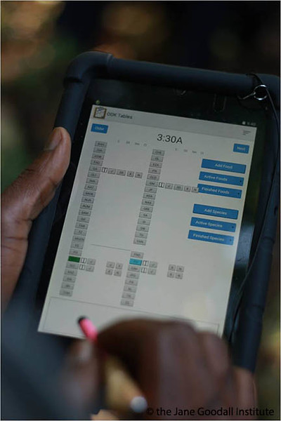
Second, if you go to the next slide, I am very excited of continuing the traditional way we have been collecting the data but improving our efficiency in leveraging some new science and technology tools. I was just at Gombe a few weeks ago and this is a picture of an app which is being used in Gombe right now which will allow us to continue the system of collecting daily data, which right now is totally paper-based, to use mobile tools which have allowed them to collect data digitally which will allow not only for much faster data collection but also the data will be immediately integrated into our database and available and the time and the cost of collecting, storing, managing, analyzing the data using sharing, collaborating would be especially of good use. I’m very excited about that and I’m looking forward to see how Gombe is embracing this new technology.
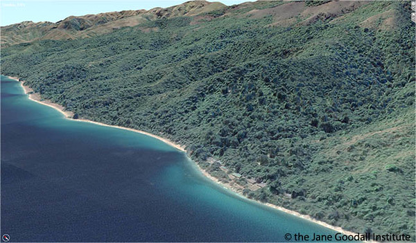
If you go to the next page, I am also excited about Gombe taking full advantage of the detailed habitat and ecological data and tools available and truly ask questions. This has conservation and ecology and landscape science and landscape ecology implications which go beyond chimpanzees. For example, what you are looking at is a two meter digital terrain model which we just received. This was developed in collaboration with DigitalGlobe and derived from 63m satellite imagery. What you see here – those bumps on the imagery – those are actually the actual tree heights and the heights of the houses from the field space which we can map now. So there is a huge amount of information which can be used again to add to our behavioral research but also ask ecological questions. There are not many places in Africa and in the forests which have such data sets available.
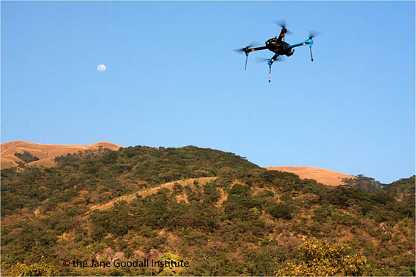
The next slide is another example of technology. I was there with conservation drones, our partners, to expand new technologies such as the UAV’s which can contribute some of the data layers for Gombe research. We’ve established that there is huge potential with the UAV’s to bridge the data that our field assistants are collecting on the ground with the satellite data coming from the satellite. This is a very exciting example of how the new technologies could contribute to research.
That’s amazing! I think the drones could at least be helpful in shortening the time it takes to find the chimps in the park, right? Potentially?
I’m not sure about that one. We were able to detect chimpanzee nests with the drones which is extremely important when you survey chimpanzees because finding a nest is one of the most challenging parts of the surveys. So finding nests from the drones could help our ability to do better surveys.
Great. Part of the reason why we are gathered is that we’re this week celebrating or starting our celebrations for the 55th anniversary of Jane’s research at Gombe. Jane’s presence in Gombe and subsequently JGI – we started off on being really focused on the science, but as we know as Jane discovered how endangered chimpanzees are, our focus switched to conservation. One of the questions we’ve heard a lot is how the behavioral studies, and you’ve touched on this a little bit in our conversation, how the behavioral studies that have been going on now for 55 years relate to the conservation work JGI is leading, not only in and around Gombe but now across the Congo Basin. And I know there is some efforts that you have with other partners in other parts of Africa as well. Can you speak to how the behavioral research connects to the conservation work?
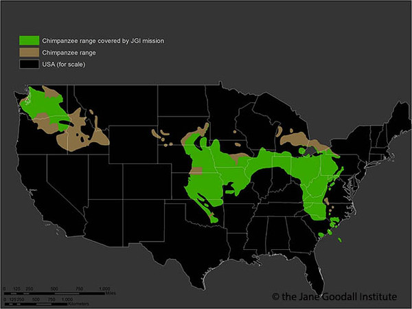
Absolutely. As I said before, without Gombe and without other long-term research sites, we have no idea what it means to be a chimp. We don’t understand; we cannot appreciate the importance of social and ecological factors that shape viability. What does it mean to be a chimpanzee and have a community or population be viable? So in this perspective, all the discoveries and continuing discoveries at Gombe have a direct impact on conservation. Not just at Gombe but also elsewhere. For example, if you go to the next slide, I already showed you the map of Gombe over Central Park. Here is an overlay of chimpanzee range over the U.S. just to show you the scale and the challenge of JGI’s mission to protect 85 percent of chimpanzees and their habitats in Africa. Just to put it into a kind of geographic context. It’s a huge challenge. There is no way we can survey chimpanzees everywhere the same to how we did it in Gombe. But what you can do – you can build models and design tools which take advantage of the little knowledge that we have a Gombe and use it to scale up that knowledge and work to protect the chimps elsewhere.
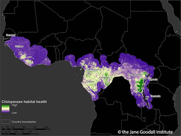
For example, if you go to the next slide, one of the projects which we are working on with a number of partners and is funded by NASA with the University of Maryland and other partners is applying some of the similar tools and similar data as we applied in Gombe conservation action plans. Now, thanks to the advances in satellite technology and image processing technology and cloud based modeling, we can do that now for the entire chimp range in Africa. And we don’t just do it once in five years, we can map it every year. So here is an example of chimpanzee habitat health index which the Jane Goodall Institute with funding from NASA is developing as a decision support system. We already mapped chimpanzee habitat every year from 2000 to 2013 and the plan is that every year we will continue to produce these habitat health layers to share with the world and inform what is the status of chimpanzee healthy habitats and what is the success of our conservation efforts.
I think the impact of Gombe also—it is important to mention that many studies now show that having boots on the ground is one of the most important factors in achieving conservation success. So just physical presence of researchers in Gombe already puts Gombe not only on the map, but also significantly contributes to the protection of chimpanzees in Gombe and outreach. That is another important contribution of long term research to conservation. Finally, what happened to Gombe is happening to many other forest patches and habitats round Africa. The solutions, lessons learned, technologies, everything that we had been doing in Gombe—trying to understand how chimps and people can coexist and do land-use plans that can support both people and chimps—is extremely important and relevant. So Gombe definitely has behavior research contributions.
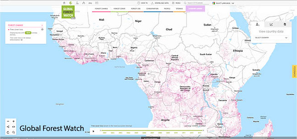
I have another example at the end if you go to the next slide. In the past, when I came as a Ph.D. student at Gombe, one of my first tasks was to acquire, process and map how the habitat changed from satellite images. I could only work with one or two or three satellite imageries. Now, thanks again to advances in technology, both computer technology but also remote sensing and web technology, we can process thousands and thousands of images so it allows us to focus not on mapping, but on using the mapping information in group conservation decisions. So for example, we are an early partner of the Global Forest Watch platform which has a goal to democratize access to the forest change information. We use the data not only for chimpanzee habitat health, but if you go to the next slide, we are using this information and combining our experience which goes back to Gombe and working with communities. We’re designing a mobile app where citizens, local communities, rangers, protected area officials could download it for free in a couple of months and be able to receive deforestation alerts on the mobile device and be able to actually go on the ground and find potential deforestation alerts and report their findings including pictures. It allows to scale up and bring more boots on the ground guided by science, guided by technology, but in order to get more presence on the ground to see how the habitats and the forests have changed.
Pretty incredible things there for not just a forest like Gombe but it sounds like across the whole chimp range. And you know with apps and technology like that, those sorts of things are available to people anywhere in the world right? Like Global Forest Watch?
Absolutely. So while we are bringing our experience and interest and applying these tools for chimpanzees, habitats in Africa, this tool – Global Forest Watch’s platform – is mobile and it works anywhere. Truly, it is an example where some of the tools and technology that we have been developing in Africa like Roots & Shoots community mapping platform and tools can be scaled up and used in many other regions.
Great. So we are coming to the end of our time. What we wanted to do was give you an opportunity to share anything else that you might want our viewers and listeners to know about Gombe as we are celebrating this anniversary and everything that is going on there. Is there anything else that you would like to share that we missed in our conversation?
I guess I just want to share that for me, Gombe was this incredible place which is not only amazing beauty and diversity—it’s history. When you walk in Gombe it’s like walking in one of Jane’s books and you see chimps and you see individuals which came alive from Jane’s books, so it’s an incredible experience on a personal level. But I think it’s important to remember that Gombe is also one of those fights which we should go back for inspiration not only to understand what is our place in nature simply because chimpanzees are our closest living relatives which is an extremely important experience. But also, Gombe is the place that we should go back to inspire conservation efforts but also to assess our assumptions and revise our assumptions about how we try to protect life on earth, because the Gombe story I believe has huge potential during that debate as well. I hope it’s going to be one of those places which we can go for inspiration and as a reference to understand how we can change the world for the better.
Great. Thank you Lilian. We really appreciate your time and your insight and kind of showing us this other side of Gombe that people probably get bits and pieces of here and there, but it’s really neat to get the big picture in the context of our Gombe 55 celebration. Thank you very much for being there with us and thank you for all of our listeners for joining in today as well. Have a great day!


